Infrastructure
Infrastructure projects such as construction of transmission tower lines, roads, large size solar system and highways require huge amount of on ground data. This includes data pertaining to land acquisition, present status, land classification, irrigation etc. All these parameters forms basic pillars for efficient project planning, execution and controlling aspects.
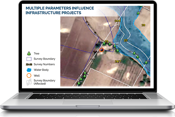
REAL® is one of the most crucial tools for the risk mitigation for the deeper understanding of the project, minor but vital challenges and reach to closer budgeting of the finances.
REAL® is a land and structure profiling platform which uses GIS and Remote Sensing technology to provide digital ata with automated geo-tagged land parcels and survey number boundaries. REAL with the help of GIS mapping is an effective tool to visualize the topographical conditions of the proposed route alignment for accurate and quick data collection experience.
REAL provides information for

Right of way

Land Use & Classification
Cadastral Maps Superimposed with satellite image

Survey Numbers Boundaries

Ownership Records

Elivation Profile
Topography
Soil Strata